Öxarfjörður
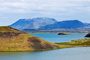
Öxarfjörður is wide fjord in North Iceland, he is located between Tjörnes peninsula in the east and Melrakkaslétta peninsula in the west. The fjord is short but about 30 kilometers wide.
Photo from www.nordurthing.is
Jökulsá river has in the past millennia brought a lot of sand into the fjord making a big flat sand area from Ásbyrgi north to where the coast line is today, this area is about 300 square kilometers and is called Austursandur on the east side of the river Jökulsá á Fjöllum and Vestursandur on the west side of the river.
The area is flat with many rivers and ponds. Two lakes are in Öxarfjörður fjord, one called Víkingavatn (the Viking lake) and the other named Skjálftavatn lake which was formed in the big earthquake in the year 1976, the earthquake is called Kópasskers earthquake, it caused considerable destruction in the region.
North Atlantic ridge passes through Öxarfjörður from South to North where the tectonic plates are moving apart causing a lot of earthquakes, this drifting area is called Tjörnesbeltið. The most famous place in Öxarfjörður is Ásbyrgi is a unique natural beauty. Some agriculture is in the Öxarfjörður area, mostly sheep farming.