Fagradalsfjall Volcano
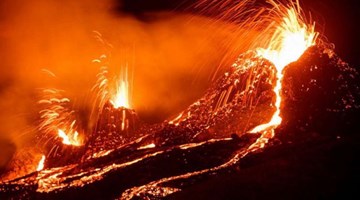
The Fagradalsfjall volcano is located in the Geldingadalur valley, in the south of the Reykjanes Peninsula, about 40 km from Reykjavík, which the capital of the country and the most populous city. The eruption began on March 19, 2021, and until today (May 4, 2021) it is still active, it is the newest volcano in Iceland.
Guided volcano adventure with lava fields, raw geology and dramatic Reykjanes landscapes.
Guided volcano adventure with lava fields, raw geology and dramatic Reykjanes landscapes.
The Reykjanes Peninsula is well known for its volcanic landscape and large lava fields. Beneath its surface there is a great volcanic and seismic activity due to the fact that the two tectonic plates, Eurasian and North American, lie just below and progressively separate from each other. Despite all this activity in the crust under the Reykjanes Peninsula, there had not been an eruption in the area for 800 years, until now.
Eruptions are generally divided into two categories, explosive or effusive.
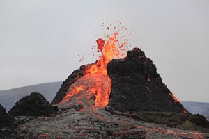
Explosive eruptions require a central volcano and generally expel large amounts of material and ash. The effusive eruptions usually occur through fissures, and the greatest dangers can be the expulsion of gases, and this is the case of the Fagradalsfjall volcano.
Effusive eruptions can be of two types depending on their duration, short or long. In the short ones we end up obtaining cones of a medium or small size or spatter cones, in the long ones, which means that they can last for years or centuries, we end up obtaining shield volcanoes, which are volcanoes that are characterized by having a huge base. As a curiosity, Mount Olympus on Mars is a shield volcano. We still don't know how long the eruption that is occurring in Fagradalsfjall will last and what we will end up obtaining.
Hiking
Currently it is a volcano suitable to be visited following the defined hiking trails and respecting the safety regulations and the instructions of the authorities, which are basically based on the emission of gases, the weather, and the direction the lava flow takes. It is an excursion without technical difficulties suitable for people of all ages who are used to walking and climbing a certain slope.
Directions
The closest town is Grindavík, from the town you have to drive the road 427, approximately 10 km, and you will find different parking areas along the road, all of them are near the beginning of the hiking trails.
To have the latest information on the situation of the eruption area, parking, access conditions and trails, visit Safe Travel, they update the information daily.