Mýrdalsjökull Glacier
Mýrdalsjökull Glacier is the fourth largest glacier in Iceland about 600 km2. The glacier is located in South Iceland to the north of the town Vík and to the east of the famous Eyjafjallajökull glacier. Underneath the glacier sleeps the powerful volcano Katla.
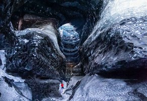
Super Jeep ride from Vík to a natural ice cave beneath Katla volcano, with glacier scenery and certified guides.
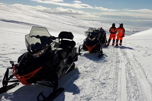
Snowmobile tour on Mýrdalsjökull glacier, an exciting day trip to the South coast of Iceland.

Ride an ATV across black sand beaches to the famous DC-3 plane wreck. A powerful South Coast adventure with wild ocean views.
Average thickness of the glacier is about 230 meters of ice and the thickest part of the glacier is about 750 meters of ice covering the caldera of Katla volcano. The highest peak of the glacier is around 1500 meters. Sólheimajökull glacier is an outlet glacier that flows from Mýrdalsjökull glacier and is popular place to Glacier Hiking.
The glacier covers one of the most powerful volcano in Iceland called Katla. Katla is very active and has erupted on average once every 60 years. Last 1000 years Katla has erupted more than 20 times and last eruption was in 1918, which is the longest time between eruptions since settlement in Iceland. Katla is very powerful and when she erupts it has very serious consequences. It is estimated that the total amount of volcanic ash in the eruption in 1918 was about 700 million cubic meters. From these eruptions huge amounts of glacier ice melts in a very short time causing big Glacier Floods that are estimated to be up to 500.000 cubic meters per second. The volcano is closely monitored and geologist suspect that it might erupt in the near future but still it is no way to tell.
Snowmobile Tours
Guided Snowmobile tours are offered all year round on Mýrdalsjökull. It is a very unique and an essential Icelandic experience. On a sunny day the view from the top of the glacier is just breathtaking over South Iceland. It is not recommended to go by yourself on the glacier as there are many crevasses on the glacier that can be very dangerous if you don't know your way around and the weather can change very fast from sunshine to heavy winds and snowstorm.