The Eyjafjöll Region
The Eyjafjöll region, which stretches from the Markarfljót river in the west to the Jökulsá river on Sólheimasandur in the east, is an area of varied landscape, nature and wildlife with a long and colourful history. The local economy is based largely on agriculture and tourism.
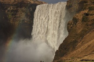
Some of Iceland’s best-known tourist attractions are in the Eyjafjöll region, such as the spectacular Skógafoss and Seljalandsfoss waterfalls, and the famed Skógar Museum. Beyond the Eyjafjöll mountains is the unspoiled upland valley of Þórsmörk, a perennial favourite with those in search of tranquillity: many visitors choose to walk from Skógar into Þórsmörk over the Fimmvörðuháls mountain pass (only in summer).
The History of the Eyjafjöll region
As elsewhere in Iceland, the history of human habitation in the Eyjafjöll region began around a thousand years ago, with the arrival of settlers from Norway on the previously-uninhabited island. The best-known of the early settlers in the Eyjafjöll region is Þrasi Þórólfsson, who is reputed to have hidden a chest of gold beneath the Skógafoss waterfall. Relatively little is known of the history of the region from the Age of Settlement around 900 AD until 1703, when the first census of Iceland’s population records that Eyjafjöll was the most populous region of Iceland, with 1,069 inhabitants. At that time the total population numbered a little over 50,000, and thus about 2% of the population lived in Eyjafjöll. The region is good agricultural land, with rich fishing grounds just off the coast, and hence living conditions were favourable at that period. At that time most farmers were tenants, leasing their farms from the two largest landowners, the church and the King of Denmark and Iceland. Only one farmer in the region owned his own land. Icelanders lived a hard life as subsistence farmers. The population remained similar until about 1900; by that time developments in the fisheries and economy and the accompanying social changes led to massive migration from rural areas into new towns and villages at the coast in search of work. Many Eyjafjöll people left for the offshore WestmanIslands at the beginning of the 20th century, when motorised vessels were revolutionising the fishing industry and an important fishing port was growing up on the islands.
As mentioned above, off the coast are rich fishing grounds, and the local farmers fished there extensively. Fishing made an important contribution to the livelihood of Eyjafjöll people, especially when times were hard in agriculture. Iceland’s south coast has no natural harbours, and hence fishermen had to launch their open boats from the sandy shore, open to the waves of the north Atlantic. The pounding surf could make it hard to difficult to bring the laden boats ashore, and it sometimes proved necessary to row out to the Westman Islands to wait for more favourable conditions. These journeys could be hazardous: in 1832 and 1890, for instance, boats foundered at the cost of many lives, and in 1901 twenty people from Eyjafjöll were drowned on their way to the Westman Islands – all people in the prime of life.
The Eyjafjöll region was rather isolated, cut off by two rivers: Markarfljót to the west and Jökulsá on Sólheimasandur to the east. Until the 20th century Iceland had neither roads nor bridges, and people travelled on foot or on horseback, so rivers had to be forded. The rivers to east and west of Eyjafjöll were difficult to ford, but the local people had no choice but to cross the rivers when travelling to the nearest market town to sell their wares and buy necessities: they could travel west to the county of Árnessýsla, or east to the village of Vík in the Mýrdalur region. Not until 1921 was the Jökulsá river bridged, opening up the route east to Vík. In 1933 the Markarfljót river was bridged, opening the way to the west. The local farmers also traded extensively in the Westman Islands; they generally set off in the evening from Fjallasandur beach, reaching the islands the following morning. It was said to take four hours to row out to the islands in calm water, but completely calm seas are a rarity. The visitors spent the day buying and selling, and called on friends on the island. Once their purchases had been loaded on the boat they rowed for the mainland in the evening, reaching home at dawn. Such journeys were, however, often disrupted by weather and conditions at sea. In high seas Eyjafjöll farmers could not return to their homes, and they might be stranded for long periods on the Westman Islands. Their families at home, of course, had no idea whether they were alive or dead. The longest known case of travellers being stranded on the Westman Islands due to weather was for 13 weeks, or over four months.
As mentioned above, the local economy has traditionally been based on agriculture. From the days of the Settlement in the middle ages until the mid-20th century, all tasks were done by hand, or with the assistance of the sturdy Icelandic horse. Mechanisation of agriculture began in the mid-20th century,
since when technological progress has been rapid. Today the population of the Eyjafjöll region has fallen: the region has fewer, larger farms. Most are
dairy farms, and there is also some sheep husbandry. In recent years tourism has been playing a growing role in the local economy, and no doubt this trend will continue in the future.
Nature and geology
The nature and geology of Eyjafjöll have much to offer. The region combines diverse forms of landscape, from the black basaltic sands of the coast and the lush green lowlands to magnificent mountain slopes and peaks, and rising up above them the snowy ice-cap. The coastal sand deserts have been formed over the centuries by massive floods caused by volcanic eruptions beneath the ice-caps of Mt. Katla (Mýrdalsjökull glacier) and Eyjafjallajökull glacier. The commonest form of rock in the region is hyaloclastite, a glassy aggregate formed by volcanic eruptions under ice. The mountains have subsequently been eroded and moulded by wind, water and ice.
The region abounds in small rivers and brooks, and it has many picturesque gullies eroded by the rivers; in addition the waterfalls of Eyjafjöll are probably more numerous and diverse than in any other region of the country. For example, Seljalandsfoss and Skógafoss waterfalls, both 62 metres high, are remarkable works of nature; but many other waterfalls are no less impressive.
Eyjafjöll has some geothermal energy resources, which have been harnessed in recent years for heating. Above the farm of Seljavellir is a unique swimming pool dating from 1922. Built into the rock wall, the pool fills with hot water from the rock. Visitors who are interested in seeing the glacier at close quarters can easily reach Sólheimajökull, a glacial tongue of the Mýrdalsjökull glacier. Gígjökull, another glacial tongue at the north of the Eyjafjallajökull glacier, is easily accessible from the road into Þórsmörk, a beautiful inland valley surrounded by mountains, which is one of Iceland’s most renowned beauty spots.
Most of Iceland’s bird species can be seen in the Eyjafjöll area: for instance the golden plover, whimbrel, oystercatcher, raven, redshank, snipe, greylag goose, great and arctic skua, and many more.
The arctic fox is found in the region, but mostly in remote and mountainous areas away from human habitation. Seals may be spotted off the shore, especially at the estuary of the Jökulsá river on Sólheimasandur. The vegetation of the region is also diverse, and wildflowers such as wood cranesbill, dandelion, buttercup, angelica, etc. are common. The climate of the Eyjafjöll area is rather mild; this is the region of Iceland where spring arrives first.
Tours Available
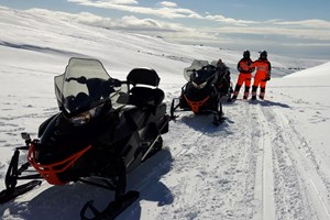
A South Coast adventure that combines classic South Iceland scenery with a real snowmobile ride on Mýrdalsjökull glacier.
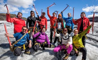
A South Coast day tour from Reykjavík with waterfalls, black sand scenery and a guided glacier walk.
A private South Coast tour with flexible pacing, strong photo stops and a more personal way to experience South Iceland.
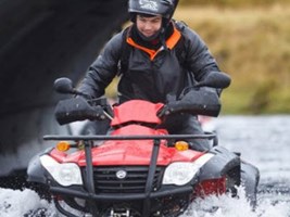
An active South Coast adventure combining ATV riding with black sand scenery and the famous DC-3 plane wreck area.