Brúarfoss Waterfall Guide: Parking, Hike & Directions
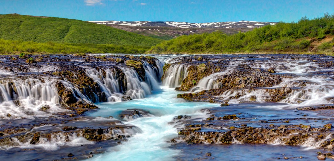
Brúarfoss is a small but striking waterfall on the Brúará river in Bláskógabyggð, between Laugarvatn and Geysir on the Golden Circle. Its drop is only about 2–3 metres, but the clear blue water spreads across dark rock before converging into a narrow central channel. That shape, colour and movement make Brúarfoss one of South Iceland's most distinctive waterfall stops.
Access has changed since this guide was first published in 2018. You can now choose between a short walk from a paid car park close to the waterfall or a longer, free riverside hike from Road 37. The old route through nearby summerhouse roads and private land is no longer the route to follow.
Brúarfoss quick guide
| Location | Beside Road 37 between Laugarvatn and Geysir, South Iceland |
|---|---|
| Short visit | Paid parking at Hlauptunga and an approximately five-minute walk |
| Long hike | About 7 km return, usually 2–3 hours, from the hiker parking by the Brúará bridge |
| Best season for the long trail | Snow-free months; the official riverside trail is closed in winter |
| Footwear | Sturdy waterproof shoes with good grip, especially after rain or in icy conditions |
| Time to allow | About 30–45 minutes for the short visit, or 2–3 hours for the full hike |
Quick links
- Parking and the short walk
- The 7 km Brúarfoss hike
- What Brúarfoss is like
- Winter access and safety
- Planning a Golden Circle visit
- Brúarfoss FAQ
Brúarfoss parking and the short walk
The closest access is the paid Brúarfoss car park at Hlauptunga, reached from Road 37 (Laugarvatnsvegur), near Hótel Efsti-Dalur. A purpose-built access road leads to the parking area, and the waterfall is approximately a five-minute walk away. Follow the signs and the marked path rather than older online directions.
Parking is monitored digitally by number plate. Pay the current rate through Parka or by following the instructions on site. The standard payment covers up to four hours; longer stays cost extra, overnight parking is not permitted, and Parka allows online payment for up to 24 hours after departure. Rates and local arrangements can change, so check the displayed information when you arrive.
The short route is the practical choice for a full Golden Circle day, travellers with limited time and anyone who does not want the longer riverside walk. Natural surfaces can still be wet, muddy or icy, and accessibility depends on the conditions on the day.
The 7 km Brúarfoss hike
The longer route starts at the designated hiker parking area on the east side of the Brúará bridge on Road 37. From there, follow the marked trail north along the east bank of the river. The walk is about 3.5 km each way, or 7 km return, and usually takes 2–3 hours.
Much of the route is on gravel, but the natural sections can become very muddy after rain. The path follows the river past smaller cascades and rapids before reaching Brúarfoss, so the journey is part of the experience. Stay on the official trail, respect all signs and fences, and do not use shortcuts through summerhouse areas or private property.
The long trail is officially closed in winter. Even during the main hiking season, weather and ground conditions can change quickly. Bring waterproof layers, water and sturdy footwear, and allow more time if the path is wet.
What to expect at Brúarfoss
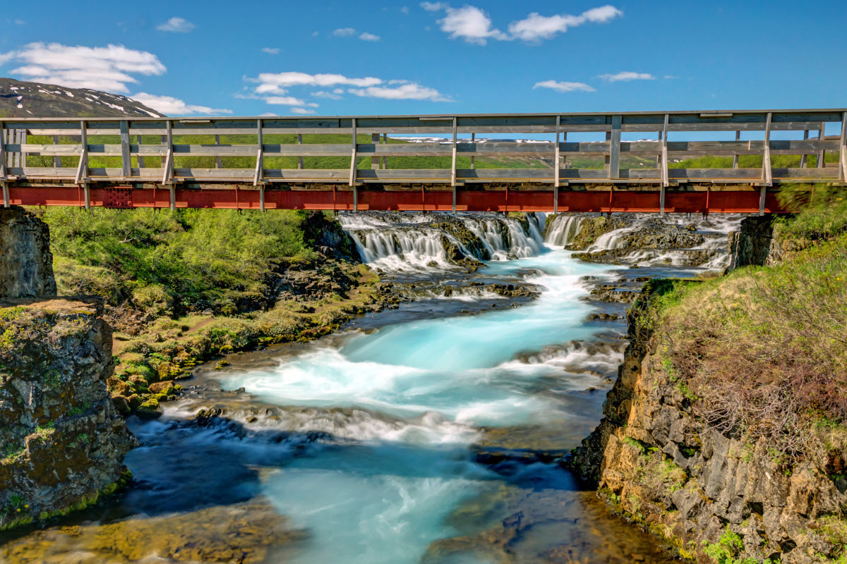
Brúará widens above the waterfall and then funnels into a narrow crack in the riverbed. The churning water appears white and turquoise against the dark volcanic rock, with the strongest view centred on the bridge. Brúarfoss is not a tall waterfall; its appeal comes from the unusual river pattern, vivid colour and close perspective.
The bridge is the clearest established viewpoint and gives a balanced view of the central channel. Early morning and late afternoon can be quieter, but light and colour vary with cloud, water level and season. Keep cameras and phones secure: spray, wet surfaces and fast water make the river edge a poor place to take risks for a photograph.
Winter access and safety
The short-access road and car park may be usable in winter when local road and weather conditions allow, but the walking surface can be icy. The 7 km riverside trail is closed during winter. Before setting out, check current road conditions and the Icelandic weather forecast.
- Wear waterproof footwear with grip; add traction aids when ice is present.
- Stay on marked paths and keep back from slippery banks and fast-moving water.
- Supervise children closely, especially on the bridge and near the river.
- Do not rely on finding toilets, food or other services at the waterfall; plan a service stop in Laugarvatn, at Geysir or elsewhere on your route.
- Leave no litter and avoid stepping onto fragile vegetation.
Planning Brúarfoss into a Golden Circle day
Brúarfoss sits roughly between Laugarvatn and the Geysir geothermal area, making it an easy detour from the classic Golden Circle. Choose the short access if you also plan to visit Þingvellir, Geysir, Gullfoss and Kerið in one day. Choose the full hike if Brúará is one of your main activities and you can give it 2–3 hours without rushing.
Nearby additions include Laugarvatn, Geysir, Gullfoss, Faxi and Friðheimar. Keep the day realistic: Icelandic road conditions, winter daylight and time spent at each stop matter more than the number of pins on a map. See our Golden Circle tour guide and tour selection for more ways to plan the area.
Golden Circle tours near Brúarfoss
The first tour below includes Brúarfoss, while the other options visit the wider Golden Circle and nearby landmarks. Routes, stops and availability can change by date, so check the individual tour before booking.
Brúarfoss video
Brúarfoss FAQ
Where do you park for Brúarfoss?
For the short walk, use the paid car park at Hlauptunga, reached from Road 37 near Hótel Efsti-Dalur. For the longer hike, use the designated hiker parking on the east side of the Brúará bridge on Road 37.
How much does Brúarfoss parking cost?
The closest car park is paid and uses number plate monitoring. Check the current rate in Parka or on the signs when you arrive, as prices can change. The standard payment covers up to four hours, and overnight parking is not allowed.
How far is Brúarfoss from the closest car park?
The marked walk from the paid Hlauptunga car park takes approximately five minutes in normal conditions.
Is there a free hiking route to Brúarfoss?
Yes. The official riverside route from the hiker parking by the Brúará bridge is about 7 km return and normally takes 2–3 hours.
Can I hike to Brúarfoss in winter?
The long riverside trail is closed in winter. The short access may be possible when roads and paths are safe, but expect ice and check conditions before travelling.
Is Brúarfoss part of the Golden Circle?
It is a short detour from the Golden Circle on Road 37, between Laugarvatn and Geysir. It is not included in every Golden Circle tour, so check the listed stops before booking.
Are there toilets or services at Brúarfoss?
Facilities and local infrastructure can change, so do not plan your day around finding services at the waterfall. Use established facilities in Laugarvatn, at Geysir or at another staffed stop.
Is Brúarfoss suitable for children?
The short walk can suit families in good conditions, but paths may be wet or icy and the river is fast. Keep children close and away from slippery banks. The longer route requires suitable footwear, weather and stamina for a 7 km walk.